Study Shows Drifter Data on Surface Currents Critical to Predict Pollutant Transport
– October 28, 2014
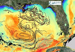
Scientists measured the speed of small, short-lived Gulf surface currents using position data from nearly 300 drifters to determine surface current impact on the dispersion of ocean contaminants.
They found that the energy contained in these fluctuating currents makes them primary contributors to the local dispersion and transport of pollutants. Drifter clusters revealed a broad, time-specific view of an area’s currents and provided data that improves transport predictions. These data could be used in real time during an event, such as an oil spill, to improve model forecasts and help contain damage. They published their findings in the August 2014 issue of Proceedings of the National Academy of Sciences: Submesoscale dispersion in the vicinity of the Deepwater Horizon spill.
The Macondo blowout released about 4.4 million barrels of oil into the Gulf over 84 days. During that time, decision-makers needed frequent, accurate forecasts about the oil’s path, travel speed, and spread rate to respond effectively. The region near the Deepwater Horizon site has an array of interacting flow patterns from large eddy-driven deep currents (such as the Loop Current), wind-driven shelf currents, and the Mississippi River plume. Satellite images of the oil slick’s movement showed that dispersal patterns were influenced by both large- and small-scale currents. Existing circulation models captured the mesoscale (larger than 10 km) flows, but the main factors controlling the region’s surface dispersion at the submesoscale (100 meters to tens of kilometers) remained unclear.
Two years after the oil spill, CARTHE researchers conducted the Grand Lagrangian Deployment (GLAD) experiment to record upper ocean flows in the presence of wind and waves. The experiment used an unprecedented number of customized GPS-equipped drifters that transmitted their locations via satellite every five minutes. The team had three deployments of ten groups of nine drifters into an approximately 8×10 kilometer area in an “S” configuration. This configuration provided a broad, time-specific view of the upper submesoscale range while minimizing the deployment time.
Accurate, incremental position and velocity data indicated the presence of energetic, local current contributions to surface dispersion on scales less than 10 kilometers in the DeSoto Canyon region. These currents were not captured by satellite imagery or ocean circulation models. Comparing the drifter data with satellite images from 2010 gave the researchers a clearer understanding of the processes that transported the oil two years earlier. The high energy of the observed submesoscale currents has significant implications for both the predictive modeling of oceanic pollutant discharges in this region and for understanding overall ocean energy transfer mechanisms.
The study’s lead author, Andrew Poje with the City of New York – College of Staten Island, explained that the GLAD experiment was explicitly designed to answer a fundamental question about how the upper ocean mixes contaminants, “Are patches of pollutants predominantly stirred by larger scale currents or are they shaken by a broad spectrum of eddies?” Poje said their results “unambiguously indicate the latter mechanism in the region studied.”
While recent research has relied on modeling to study submesoscale dynamics, the GLAD experiment demonstrated that deploying large clusters of drifting instruments to gather time-sensitive data about ocean surface currents is an effective and low-cost method to study surface flows. “Our results conclusively show that ocean flows at small scales, below 10 kilometers, contain significant energy fluctuations to control the initial spread of pollutant clouds,” said Tamay Özgökmen, with the University of Miami Rosenstiel School of Marine & Atmospheric Science and the principal investigator of the project. “Now that we have quantified this missing piece of the puzzle, we can improve our real-time predictive capabilities in the event of a future oil spill.”
The study’s authors are Andrew C. Poje, Tamay M. Özgökmen, Bruce Lipphardt, Jr., Brian K. Haus, Edward H. Ryan, Angelique C. Haza, Gregg Jacobs, A.J.H.M. Reniers, Josefina Olascoaga, Guillaume Novelli, Annalisa Griffa, Francisco J. BeronVera, Shuyi Chen, Pat Hogan, Emanuel Coelho, A.D. Kirwan, Jr., Helga Huntley, and Arthur J. Mariano.
************
This research was made possible in part by a grant from BP/The Gulf of Mexico Research Initiative (GoMRI) to the Consortium for Advanced Research on Transport of Hydrocarbon in the Environment (CARTHE). The GoMRI is a 10-year independent research program established to study the effect, and the potential associated impact, of hydrocarbon releases on the environment and public health, as well as to develop improved spill mitigation, oil detection, characterization and remediation technologies. An independent and academic 20-member Research Board makes the funding and research direction decisions to ensure the intellectual quality, effectiveness and academic independence of the GoMRI research. All research data, findings and publications will be made publicly available. The program was established through a $500 million financial commitment from BP. For more information, visit https://gulfresearchinitiative.org/.
© Copyright 2010- 2017 Gulf of Mexico Research Initiative (GoMRI) – All Rights Reserved. Redistribution is encouraged with acknowledgement to the Gulf of Mexico Research Initiative (GoMRI). Please credit images and/or videos as done in each article. Questions? Contact web-content editor Nilde “Maggie” Dannreuther, Northern Gulf Institute, Mississippi State University (maggied@ngi.msstate.edu).


