Study Finds “Business as Usual” for Hypoxic Zone Following Deepwater Horizon
– JULY 31, 2018
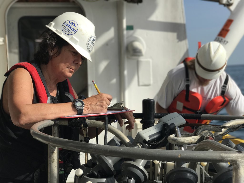 Study author Nancy Rabalais records information as they collect water samples to monitor the hypoxic zone. Photo provided by Rabalais. |
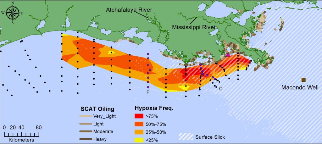 General area of bottom-water hypoxia in the northern Gulf of Mexico. Yellow and red shades: frequency of bottom-water hypoxia from 1985-2014. White lines: surface slick from Macondo well (brown square). Light and brown shading: The level of shoreline oiling from May 2010-May 2012. More details available on Figure 1 in the study. |
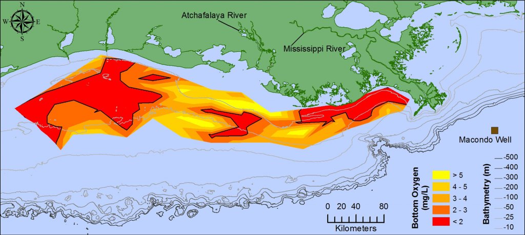 Bottom-water dissolved oxygen concentration for July 25–31, 2010. The hypoxic area is denoted by the black contour line. More details available in Figure 2 of the study. |
Researchers compared long-term data from low-oxygen (hypoxia) studies to determine if the Deepwater Horizon incident affected the Gulf of Mexico seasonal hypoxic area. Though the 2010 hypoxic area was greater in size than the historical average, it was still smaller than expected, likely due to Tropical Storm Bonnie’s disruption. Hydrocarbon concentrations were higher in May 2010 than June and July, but oxygen concentrations remained the same across all three months. Factors that influence an increase in hypoxia development – higher river discharge and nutrient loads, calmer winds and seas, and stratification – were consistent in 2010 compared to previous years. While the study did not prove or disprove that the oil spill affected summer bottom-water hypoxia, it did suggest that 2010 was not an anomalous year compared to historical data. The researchers published their findings in Continental Shelf Research: The Deepwater Horizon oil spill and Gulf of Mexico shelf hypoxia.
“As the Deepwater Horizon oil spill extended into summer, oil-mousse residue was evident in the Louisiana Bight west of the Mississippi River, and small dissolved oxygen anomalies were detected at the depth of the deep-water plume,” said study author Nancy Rabalais. “The media became engaged with the idea that the oil might complicate or worsen summertime bottom-water hypoxia on the Louisiana shelf west of the Mississippi River. There were several unfounded conclusions, as in other aspects of the effects of the oil spill, that hypoxia would worsen. Other researchers, including myself, put out a white paper on why the oil spill was not likely to affect hypoxia. The chance to test this prediction came in July 2010.”
The study team combined multi-year (1985 – 2014) hydrographic data from monthly transects off Terrebonne Bay and Atchafalaya Bay with conditions observed in May, June, and July of 2010, complemented with bottom- and surface-water aromatic and alkane hydrocarbon data. They used an empirical orthogonal function (EOF) analysis to understand interactions within a complex system by examining a smaller number of variables.
Hydrocarbons did not explain much of the variability among months compared to the Mississippi River nitrate load in May, the June-July river discharge, the wind speed or mixing conditions two weeks before the monitoring, and the surface salinity and stratification (conditions that maintain hypoxia).
The primary factors associated with a larger bottom-area of hypoxia in July of most years were Mississippi River nitrate+nitrite load (in May), ammonium, phosphate load (in May), and water discharge (in June and July). Smaller size hypoxic areas (including 2010) were associated with high wind velocity and wind gusts (associated with tropical storms and hurricanes), predominant westerly winds (that force the bottom-water hypoxic area to the east and reduce its footprint), and with drought years.
Rabalais explained that their results highlight why caution should be taken in naming Deepwater Horizon as a contributing factor in before-and-after comparisons, especially without good exposure data. She also noted that three decades of funding and a commitment to long-term data acquisition to better understand hypoxia and the northern Gulf of Mexico have made it possible to study environmental disturbances, including the Deepwater Horizon incident, in a historical framework.
Data are publicly available through the Gulf of Mexico Research Initiative Information & Data Cooperative (GRIIDC) at doi:10.7266/N7JS9NCH, doi:10.7266/N7W66HP0, doi:10.7266/N7M32SWZ, doi:10.7266/N7GF0RKZ, and doi:10.7266/N7BP00W2.
The study’s authors are Nancy N. Rabalais, Leslie M. Smith, and R. Eugene Turner.
************
This research was made possible in part by a grant from the Gulf of Mexico Research Initiative (GoMRI) to the Coastal Waters Consortium II (CWC II). Other funding sources include the National Oceanographic and Atmospheric Administration (NOAA) Coastal Ocean Program and Center for Sponsored Coastal Ocean Research (NA06OP0528, NA09NOS4780204, NA06OP0529, and NA09NOS4780230).
The Gulf of Mexico Research Initiative (GoMRI) is a 10-year independent research program established to study the effect, and the potential associated impact, of hydrocarbon releases on the environment and public health, as well as to develop improved spill mitigation, oil detection, characterization and remediation technologies. An independent and academic 20-member Research Board makes the funding and research direction decisions to ensure the intellectual quality, effectiveness and academic independence of the GoMRI research. All research data, findings and publications will be made publicly available. The program was established through a $500 million financial commitment from BP. For more information, visit https://gulfresearchinitiative.org/.
© Copyright 2010-2018 Gulf of Mexico Research Initiative (GoMRI) – All Rights Reserved. Redistribution is encouraged with acknowledgement to the Gulf of Mexico Research Initiative (GoMRI). Please credit images and/or videos as done in each article. Questions? Contact web-content editor Nilde “Maggie” Dannreuther, Northern Gulf Institute, Mississippi State University (maggied@ngi.msstate.edu).


