Study Documents How Riverine Fronts Influence Oil Transport Pathways
– SEPTEMBER 11, 2018
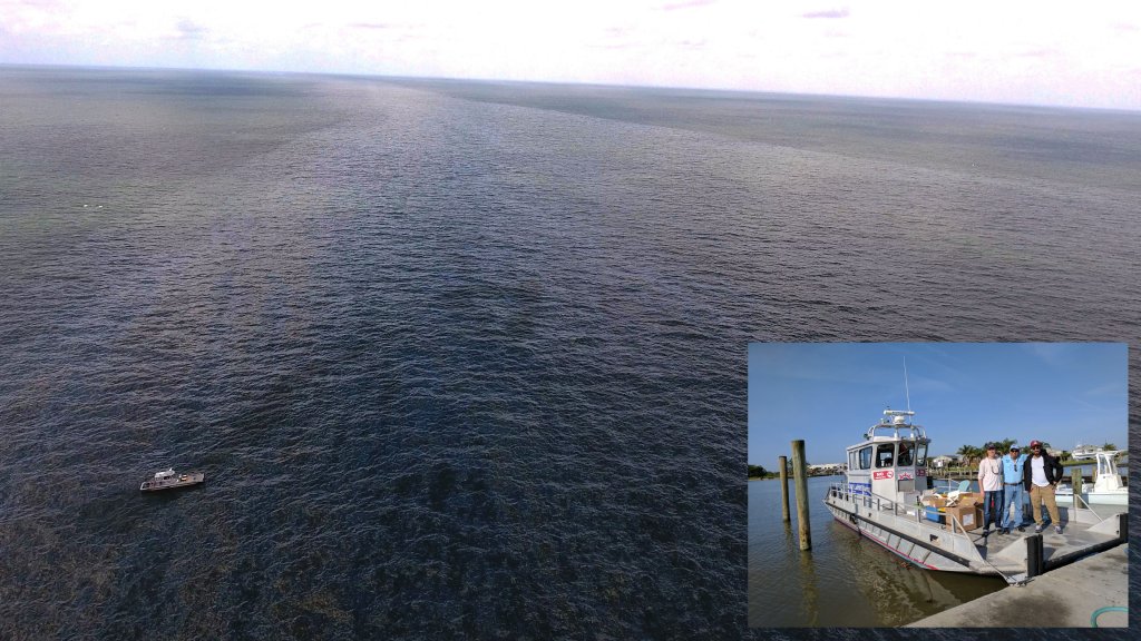 (Inset) Some of the study authors onboard a vessel used during their April 2017 field work (L-R Matthieu Le Hénaff, Oscar Garcia-Pineda, and Yannis Androulidakis). The larger picture shows oil moving in a current influenced by the Mississippi River plume. Photo by Oscar Garcia-Pineda. |
Scientists used drifters, drones, satellite imagery, and air/water measurements to investigate how local and regional ocean processes in the Gulf of Mexico influence where surface oil from the leaking Taylor Energy Site travels. The multiplatform observations documented three distinct transport pathways created by fronts, which developed from strong density differences between brackish water masses and clearer high-salinity ocean waters. Multiple river fronts influenced the final destinations of drifters and oiled waters, trapping and directing them either westward or eastward and preventing them from reaching the Mississippi River Delta. The team measured and evaluated oil thickness and updated oil drift algorithms, which, for the first time, are being included in high resolution model simulations of circulation and oil drift and could greatly improve future oil transport monitoring and predictions. The researchers published their findings in the Journal of Geophysical Research: Oceans: Influence of river‐induced fronts on hydrocarbon transport: A multiplatform observational study.
The Taylor Energy Site is near the Mississippi River Delta and its oil rig was damaged by Hurricane Ivan in 2004. Since then, oil slicks and sheens have persistently formed on the sea surface around the site, providing a natural laboratory for studying oil slick interactions with riverine fronts. Understanding the dynamic physical processes in this region is important because oil exploration often takes place near river deltas around the world.
The team conducted their field work in April 2017, tracking rapid changes of spreading oil in tandem with changes in riverine fronts and surface currents. Their multiplatform experiment included drifters (some developed by the CARTHE research group and some provided by the Norwegian Meteorological Institute), shipboard radar sea-surface roughness imagery, thermohaline measurements, and high-resolution satellite data from multiple sensors. The team derived transport pathways from drifter trajectories and derived the distribution of surface currents and spreading oil from marine radar and high-resolution satellite data, which also detected multiple river fronts.
“This field study provided unprecedented details on how fronts created by the spreading of river waters in the Gulf of Mexico could influence the transport of hydrocarbons and their pathways toward the Gulf coasts” said study author Villy Kourafalou.
The interdependencies among riverine front locations, oil slick proximity, prevailing winds, and regional circulation generated the initial transport pathways that determined oil fate. Transport pathways extended to the east and west of the Mississippi River Delta and followed major currents, which the Mississippi River plume influenced. The more dominant westward pathway along the downstream river plume current moved drifters towards the Louisiana-Texas coasts. The second pathway along the upstream river plume front moved drifters towards the Mississippi-Alabama-Florida coasts. The third pathway, influenced by the Loop Current, moved drifters southward toward the Gulf interior. This pathway indicates the possibility that oil from a future spill in this area could travel to remote southern Gulf regions and through the Straits of Florida toward the Atlantic Ocean.
The results suggest that when spills happen in areas near large rivers (as did the Deepwater Horizon incident), the fronts and currents driven by river outflows strongly influence the oil’s surface spreading.
Understanding the dynamic processes in the northern Gulf of Mexico and the Mississippi River Delta, with its complicated topography and environmentally sensitive regions, is a key part of improving transport predictions as lead author Yannis Androulidakis explained, “Being able to document the transport of oil under complex oceanographic conditions offers valuable information that can be used for preparation, prediction, and response. The knowledge of the mechanisms that control the fate of oil is necessary for the monitoring of spills and crucial for the efficient planning of both short-term and long-term protection measures.”
Read about how this study was conducted in conjunction with the last of four CARTHE experiments that bridged the processes driving surface currents from the deep ocean, across the shelf, and towards shore: Science at Sea: SPLASH Experiment Improves Predictions for Oil Moving toward Shore.
Here is a video that shows how some of this research unfolded.
In related research, read about a recently published trio of studies that described the submesoscale dynamics between the northern Gulf of Mexico and regional river systems:
- Regional and seasonal characterization and the role of river outflow (Barkan et al., 2017)
- Temperature-salinity relations and cross-shelf transport processes (Barkan et al., 2017)
- Lagrangian implications (Choi et al., 2017)
Data are publicly available through the Gulf of Mexico Research Initiative Information & Data Cooperative (GRIIDC) at doi:10.7266/N7GH9GC2, doi:10.7266/N74J0CKB, and doi:10.7266/N7V69H4N.
The study’s authors are Yannis Androulidakis, Vassiliki Kourafalou, Tamay Özgökmen, Oscar Garcia-Pineda, Björn Lund, Matthieu Le Hénaff, Chaunmin Hu, Brian K. Haus, Guillaume Novelli, Cedric Guigand, HeeSook Kang, Lars Hole, and Jochen Horstmann.
************
This research was made possible in part by a grant from the Gulf of Mexico Research Initiative (GoMRI) to the Consortium for Advanced Research on Transport of Hydrocarbon in the Environment II (CARTHE II) and the University of Miami Rosenstiel School of Marine and Atmospheric Science for their project Influence of River Induced Fronts on Hydrocarbon Transport. Other funding sources include the Physical Oceanography Division at NOAA’s Atlantic Oceanographic and Meteorological Laboratory.
The Gulf of Mexico Research Initiative (GoMRI) is a 10-year independent research program established to study the effect, and the potential associated impact, of hydrocarbon releases on the environment and public health, as well as to develop improved spill mitigation, oil detection, characterization and remediation technologies. An independent and academic 20-member Research Board makes the funding and research direction decisions to ensure the intellectual quality, effectiveness and academic independence of the GoMRI research. All research data, findings and publications will be made publicly available. The program was established through a $500 million financial commitment from BP. For more information, visit https://gulfresearchinitiative.org/.
© Copyright 2010-2018 Gulf of Mexico Research Initiative (GoMRI) – All Rights Reserved. Redistribution is encouraged with acknowledgement to the Gulf of Mexico Research Initiative (GoMRI). Please credit images and/or videos as done in each article. Questions? Contact web-content editor Nilde “Maggie” Dannreuther, Northern Gulf Institute, Mississippi State University (maggied@ngi.msstate.edu).


