Drifters in Path of Hurricane Isaac Provide New Insights on Ocean Currents
– August 28, 2012
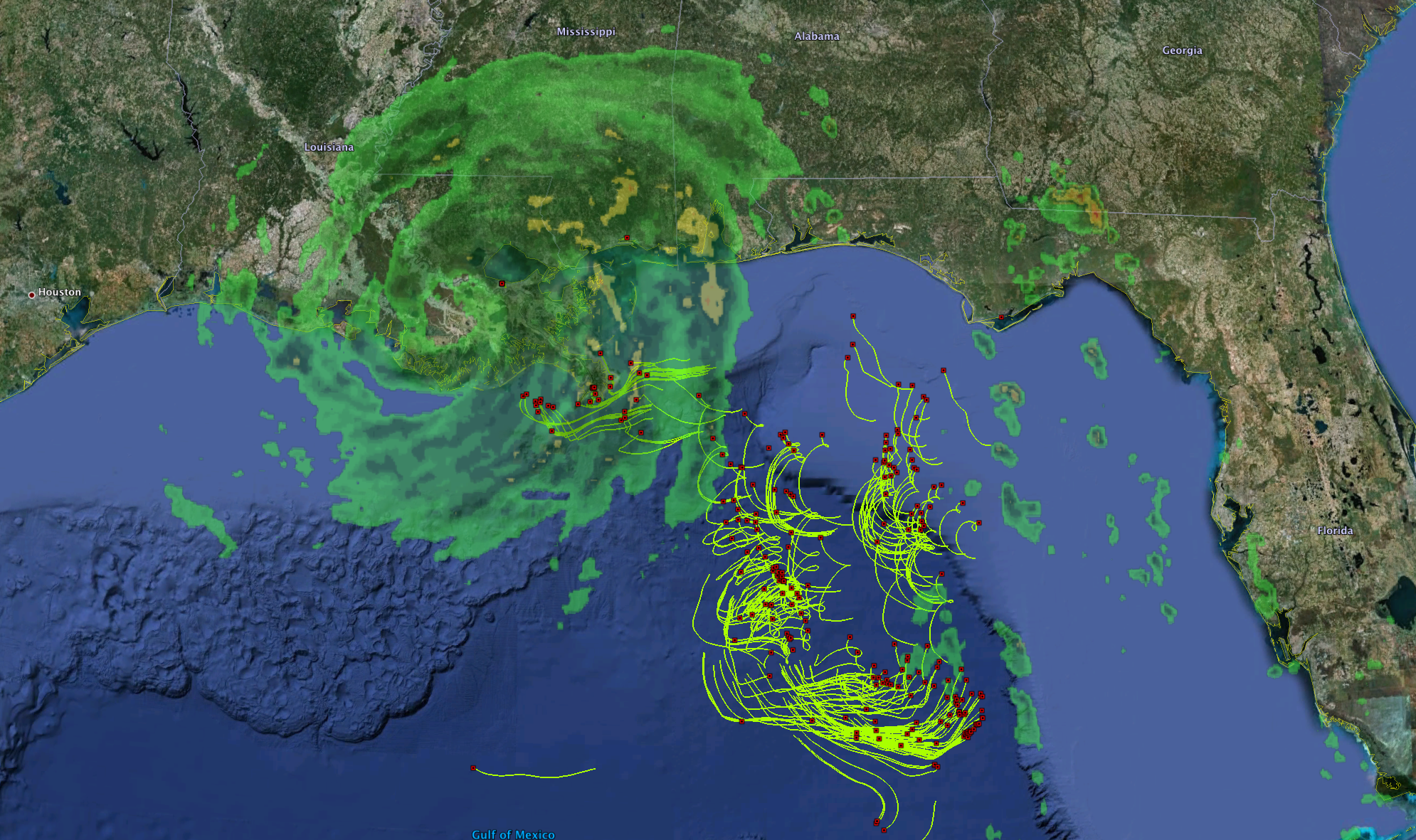 (Click to enlarge) |
(UPDATED ANIMATION: 8/30/12) — Hurricanes can pose significant risks to human and environmental health. However, a scientific “silver lining” exists in the midst of Hurricane Isaac: the largest surface drifter deployment experiment in history is collecting data right now that will increase our understanding of ocean flows and atmospheric conditions on the surface of the ocean during a hurricane.
This experiment could help emergency responders and researchers better predict hurricane impacts on coastal regions, with the potential to protect public health and the environment in the process.
The above image shows a snap-shot of the location of oceanic drifters which transmit every five minutes from near-surface currents – and now hurricane conditions – in the Gulf of Mexico. The drifters have moved along the currents in the Gulf from their initial deployment near the Deepwater Horizon site. Researchers with the CARTHE project are examining atmospheric conditions and the ocean’s transport arising from a combination of surface currents and waves as a means of understanding dispersion of pollutants in the Gulf.
These drifters are poised to capture new and exciting data about hurricane impacts on ocean surface flows, providing researchers with real-time, ground-truthed information. This may lead to better prediction models for improved emergency response in order to address public health and safety needs. This data can be used to supplement and fill gaps from traditional land-based radar and satellites.
The animation below shows the movement of drifters as Hurricane Isaac moves through the Gulf of Mexico.

(Click to view full size animation) The diamond shape shows the center of Isaac, while yellow circles mark the position of CARTHE drifters with three-day long trajectories. 24 August 00:00 GMT to 30 August 12:00 GMT.
In July 2012, researchers with the CARTHE project (Consortium for Advanced Research on Transport of Hydrocarbon in the Environment) released over 300 drifters and initiated the largest upper-ocean dispersion experiment of its kind, the Grand Lagrangian Deployment (GLAD). Anticipating a major weather event, researchers planned the deployment of the drifters at this time of the year to look at how a storm or hurricane might affect pollutants should such weather impact the Gulf region following an oil spill or other pollution event.
These customized drifters will continue to map currents for the next three to four weeks, adding to our understanding of the role of the atmosphere and oceanic flows in spreading and dispersing pollutants and materials near the surface of the ocean. This experiment, an observation of upper-ocean transport processes, is a critical step in improving predictions about and response to oil spills.
Read more about this ground-breaking experiment:
Two stories on the GoMRI website: Follow the Journey of CARTHE Drifters in the Gulf and CARTHE at Sea: A Grand Experiment for Transformative Research in Gulf Oil Studies and a description of the GLAD Project on the CARTHE website.
This research is made possible by a grant from BP/The Gulf of Mexico Research Initiative. The GoMRI is a 10-year, $500 million independent research program established by an agreement between BP and the Gulf of Mexico Alliance to study the effects of the Deepwater Horizon incident and the potential associated impact of this and similar incidents on the environment and public health.
© Copyright 2010- 2017 Gulf of Mexico Research Initiative (GoMRI) – All Rights Reserved. Redistribution is encouraged with acknowledgement to the Gulf of Mexico Research Initiative (GoMRI). Please credit images and/or videos as done in each article. Questions? Contact web-content editor Nilde “Maggie” Dannreuther, Northern Gulf Institute, Mississippi State University (maggied@ngi.msstate.edu).


