Study Describes Oil Slick Differences in Natural Seeps and Deepwater Horizon
– DECEMBER 13, 2016
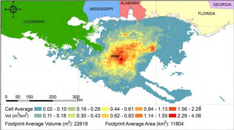 Figure 3 in the publication. Map of surface oil from Deepwater Horizon across a cumulative footprint of 149,000 square kilometers, April 24, 2010 to 3 August 3, 2010. Provided by Ian MacDonald. |
Scientists analyzed synthetic aperture radar satellite (SAR) imagery to compare the magnitude and distribution of floating oil from natural seeps in the Gulf of Mexico and the Deepwater Horizon spill. They found fundamental differences in the surface footprints of chronic background sources (seeps) and large transient anthropogenic discharges (Deepwater Horizon). They published their findings in Journal of Geophysical Research: Oceans: Natural and unnatural oil slicks in the Gulf of Mexico.
The study team reviewed 166 SAR images and found 914 persistent natural seeps across the Gulf (from 1997-2007). These seeps collectively discharged about 500,000 barrels of oil per year and covered approximately 775 square kilometers of ocean surface. Over 90% of these seeps are located west of the Mississippi River delta, well away from the Macondo well. The researchers estimated that slicks from these seeps had an estimated average thickness of 0.1 millimeter (about 1/1000th the thickness of a human hair) and remained near their source, dispersing in 8-24 hours by natural processes.
The Deepwater Horizon spill released several million barrels of oil during 83 days from a single point and covered an average of 11,200 square kilometers of ocean surface. Approximately 30%-50% of this oil reached the ocean surface with an average thickness of approximately 70 millimeters. Subsea dispersant treatments, recovery, and burning operations reduced surface oil volume but increased the distribution area for the remaining oil.
The study authors acknowledged that determining oil thickness on surface waters is very challenging. However, the technology to do so has improved as author Ian MacDonald explained, “SAR can see through clouds and works in darkness. SAR detects layers of oil because oil tends to flatten out the waves and ripples on the ocean surface.”
The team created an animation of Deepwater Horizon surface oil, updated every 12 hours, from April 24 to August 2, 2010. The animation demonstrates the effects of wind and response efforts, particularly dispersant injection, on surface oil as MacDonald explained, “When we compared two periods of equivalent wind speeds before and after subsea dispersant application, which began around 2 June 2010, we see that the volume of surface oil decreased by 21% after subsea dispersant treatments. However, the area over which the remaining oil was distributed increased by 49%.”
Video Credit: Animation provided by Ian MacDonald
Data used in this study are available as supporting information in Data Sets 1, 2A, 2B, and Movie S1 and at GRIIDC dataset doi:10.7266/N7KW5CZN. Satellite images listed in supporting information Table S1 are archived at the Alaska Satellite Facility. Interpretations of satellite images listed in supporting information Table S2 can be viewed at http://gomex.erma.noaa.gov/.
The study’s authors are Ian MacDonald, Oscar Garcia-Pineda, A. Beet, Samira Daneshgar Asl, L. Feng, G. Graettinger, D. French-McCay, J. Holmes, Chuanmin Hu, F. Huffer, L. Leifer, Frank Muller-Karger, A. Solow, Mauricio Silva, and G. Swayze.
************
This research was made possible in part by a grant from the Gulf of Mexico Research Initiative (GoMRI) to the Ecosystem Impacts of Oil and Gas Inputs to the Gulf-2 (ECOGIG-2) consortium. Other funding sources included the Department of Energy National Energy Technology Laboratory (DE-NT0005638), the National Science Foundation (EF-0801741), the Bureau of Ocean Energy Management (M12PC00003), the National Oceanic and Atmospheric Administration, and the National Aeronautics and Space Administration (NNX13AD08G).
The Gulf of Mexico Research Initiative (GoMRI) is a 10-year independent research program established to study the effect, and the potential associated impact, of hydrocarbon releases on the environment and public health, as well as to develop improved spill mitigation, oil detection, characterization and remediation technologies. An independent and academic 20-member Research Board makes the funding and research direction decisions to ensure the intellectual quality, effectiveness and academic independence of the GoMRI research. All research data, findings and publications will be made publicly available. The program was established through a $500 million financial commitment from BP. For more information, visit https://gulfresearchinitiative.org/.
© Copyright 2010-2017 Gulf of Mexico Research Initiative (GoMRI) – All Rights Reserved. Redistribution is encouraged with acknowledgement to the Gulf of Mexico Research Initiative (GoMRI). Please credit images and/or videos as done in each article. Questions? Contact web-content editor Nilde “Maggie” Dannreuther, Northern Gulf Institute, Mississippi State University (maggied@ngi.msstate.edu).


