Study Detects Drifter Drogue Loss and Produces More Accurate Surface Ocean Transport Data
– DECEMBER 20, 2018
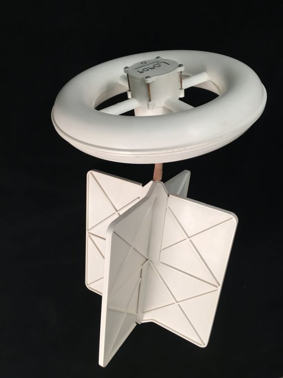 A CARTHE drifter with all of its components. Image provided by Angelique Haza. |
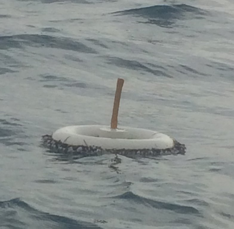 An upside down CARTHE drifter that lost its drogue in the Gulf of Mexico. Photo provided by Angelique Haza. |
Scientists developed a two-stage algorithm that identified the status of drogues attached to ocean drifters deployed during the Lagrangian Submesoscale Experiment (LASER). The LASER field study was hampered by bad weather conditions resulting in 40% of drifters losing their drogues, which caused them to move differently than drifters with drogues. The first algorithm stage identified drifters as “drogued” or “undrogued” based on GPS transmission rates and average downwind velocity. The second stage determined the status of unclassified drifters by comparing their velocities to those of nearby classified drifters. The team validated the algorithm, found 94 – 100% accuracy, and used their analyses to produce two datasets that represented different upper-ocean transport processes (the upper 60 cm and the upper 5 cm), which can improve wind-based ocean modelling and oil spill response.
The researchers published their findings in the Journal of Atmospheric and Oceanic Technology: Drogue-loss detection for surface drifters during the Lagrangian Submesoscale Experiment (LASER).
Researchers deployed 1,000+ biodegradable drifters during LASER, each having a satellite-tracking surface floater that extended 5 cm below the surface and a drogue extending 60 cm below the surface. Strong storms and large waves associated with the 2016 El Niño event tended to flip drifters that had lost their drogues upside down (pointing the satellite antenna downward) and then flip them again (returning the antenna upward).
Because drogued and undrogued drifters moved in different ways, it was important to identify which drifters lost their drogues and when, as that would significantly affect the team’s analyses. To do so, they used simulations from a coupled ocean-atmosphere wave model, anomalous GPS signal intermittency, high-cumulative wind/wave induced speeds, relative velocity of nearby drifters, and visual motion comparisons.
“The upper meter of the ocean is notoriously difficult to measure, but it plays a central role in the transport of oil from spills,” explained study author Angelique Haza. “By taking advantage of the group motion, we were able to develop algorithms to detect which drifters were moving unlike the rest, thereby pinpointing the moment of drogue loss. Now that we have accurately created two effective data sets within LASER drifters, a number of studies and dissertations are coming up describing how the dynamics work in the upper 1-meter of the ocean.”
Drifters without drogues exhibited reduced transmission rates, relatively fast downwind velocities, and only sampled the upper 5 cm flow, as compared to 60 cm that drifters with drogues sampled. The undrogued drifters moved faster during strong wind events than drifters with drogues, which tended to align along fronts that were impervious to wind and wave effects.
Haza described the results, “The LASER data set contains about 500 drifters in each category (drogued and undrogued), and it is unique by the sheer number of drifters and their duration to describe upper ocean transport at two depths (5 cm and 60 cm). These results help us better understand vertical shear in the upper meter circulations, the role of wind and waves at the surface, and how we can improve wind-based parameterizations in ocean models. Regarding oil spill response, the drogued drifters characterize short-term oil behavior when the oil is dispersed over the top 1 m of the water column, and undrogued drifters represent the movement of surface oil. Accumulation of surface oil along convergence zones allows for easier recovery, while oil entrainment at the very surface can more easily be predicted with a good wind product.”
Data are publicly available through the Gulf of Mexico Research Initiative Information and Data Cooperative (GRIIDC) at doi:10.7266/N7MS3R6V, doi:10.7266/N7W0940J, doi:10.7266/N7QN656H, and doi:10.7266/N7KW5DH7.
The study’s authors are A.C. Haza, E. D’Asaro, H. Chang, S. Chen, M. Curcic, C. Guigand, H.S. Huntley, G. Jacobs, G. Novelli, T.M. Ozgokmen, A.C. Poje, E. Ryan, and A. Shcherbina.
By Nilde Maggie Dannreuther and Stephanie Ellis. Contact maggied@ngi.msstate.edu with questions or comments.
************
This research was made possible in part by a grant from the Gulf of Mexico Research Initiative (GoMRI) to the Consortium for Advanced Research on Transport of Hydrocarbon in the Environment II (CARTHE II).
The Gulf of Mexico Research Initiative (GoMRI) is a 10-year independent research program established to study the effect, and the potential associated impact, of hydrocarbon releases on the environment and public health, as well as to develop improved spill mitigation, oil detection, characterization and remediation technologies. An independent and academic 20-member Research Board makes the funding and research direction decisions to ensure the intellectual quality, effectiveness and academic independence of the GoMRI research. All research data, findings and publications will be made publicly available. The program was established through a $500 million financial commitment from BP. For more information, visit https://gulfresearchinitiative.org/.
© Copyright 2010-2018 Gulf of Mexico Research Initiative (GoMRI) – All Rights Reserved. Redistribution is encouraged with acknowledgement to the Gulf of Mexico Research Initiative (GoMRI). Please credit images and/or videos as done in each article. Questions? Contact web-content editor Nilde “Maggie” Dannreuther, Northern Gulf Institute, Mississippi State University (maggied@ngi.msstate.edu).


