Research on Oil Transport that Informs Spill Response
– April 20, 2015
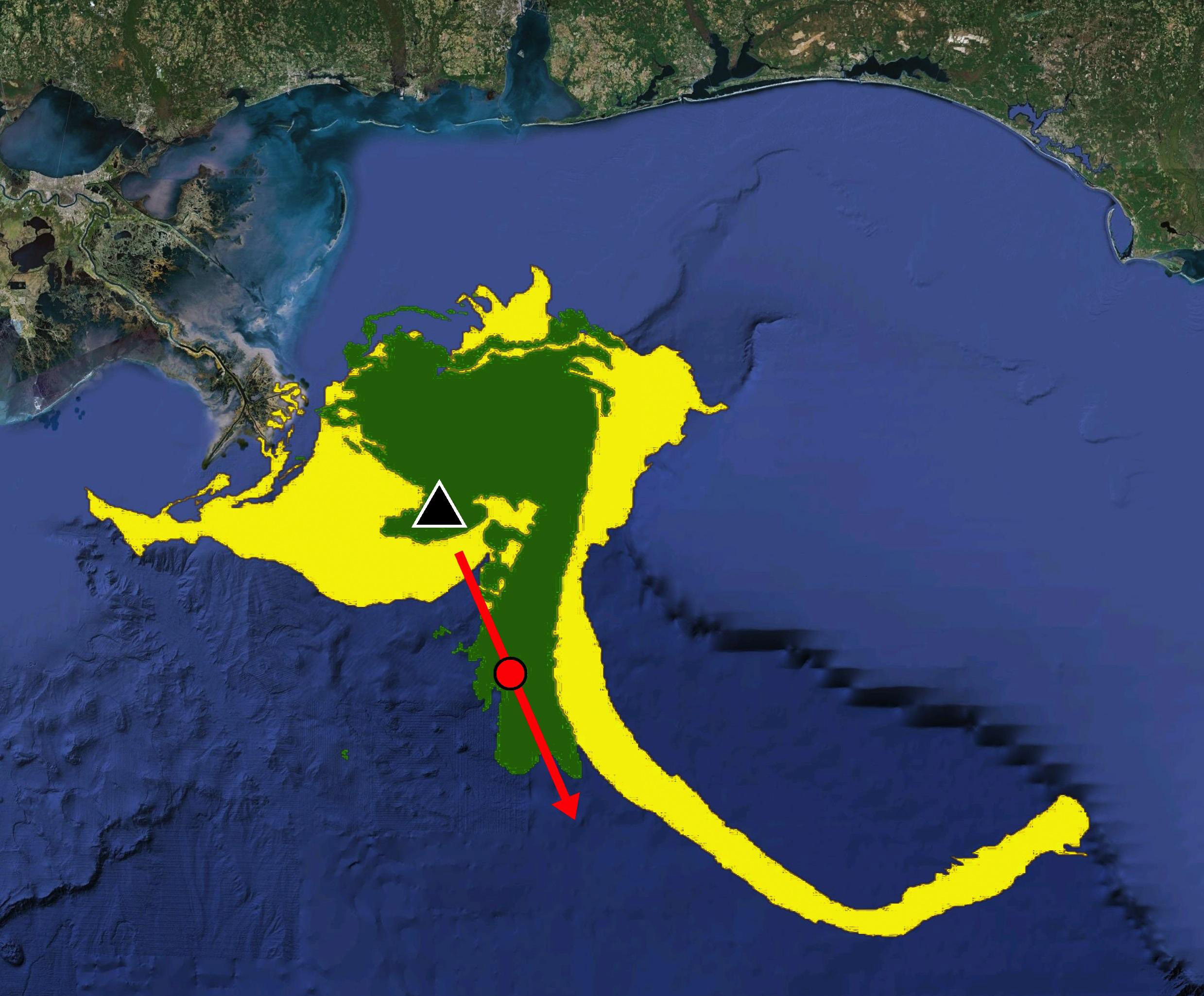 (Click to enlarge) This image incorporates data on Lagrangian coherent structures or LCS (in red) onto a simulation of the oil slick (in green) following the Deepwater Horizon oil spill. Data from the LCS-core analyses forecasted the subsequent formation and movement of the oil slick (in yellow) sometimes referred to as the “tiger tail.” (Image by Dr. Maria Josefina Olascoaga. Data acknowledgement to Geoffrey Samuels and the Center for Southeastern Tropical Advanced Remote Sensing (CSTARS) in Miami, FL) |
The first in a three-part series of GoMRI science-for-response articles
If another oil spill were to occur in the Gulf of Mexico today, have there been scientific advances and new tools developed that could better inform response decisions? Have communication and collaboration among scientists and responders improved? Yes and yes.
Recently, consortia directors and leads for smaller-group projects funded by the Gulf of Mexico Research Initiative (GoMRI) talked about how their science could be used to inform an oil spill response. This article focuses on the science advances and tools related to oil transport that can inform response decisions in the case of future oil spills. It is the first in a three-part series of GoMRI science-for-response articles. The second article will be Research on Dispersants that Informs Oil Spill Response and the third article will be Research on Oil Biodegradation and Monitoring that Informs Spill Response.
COMMUNICATION AND COLLABORATION are critical for getting science to the right people at the right time during an emergency response. The Deepwater Horizon oil spill revealed challenges in these areas, as C-IMAGE director Steven Murawski explained:
During the oil spill, there was a strained relationship between academia and responders. The most important factor in response is to have people with different perspectives working together. You can have the most impressive widgets in the world, but if people can’t work together then none of them are relevant.
Before responders can use science to inform decisions, they have to know about it, understand its usefulness, and have access to it quickly. While discussing recent science advances, the researchers were quick to note that there are many signs of progress being made in these working relationships.
KNOWING WHERE OIL IS AND WHERE IT WILL GO is critical for response, and GoMRI-funded research has improved tracking and prediction capabilities for both surface and sub-surface oil transport.
Understanding the Gulf’s surface currents in open and nearshore waters and their influence on oil movement has been the focus of two CARTHE experiments, GLAD and SCOPE, which involved the deployment and tracking of GPS-enabled drifters. CARTHE director Tamay Ozgokmen explained that using drifters in a spill area is an efficient and safe means for gathering real time data that decision makers can use for response:
Drifters can be used in calm or stormy weather, day or night. Our GLAD experiment tracked upper ocean flows. These data were assimilated into ocean circulation models and improved operational model accuracy and transport predictions and our understanding influences on coastal dispersion. These findings are important because the oil didn’t spread everywhere.
Ozgokmen described increased efforts that integrate scientists with the response community to make useful science and products that are available to others:
Our advisory board includes representatives from the Coast Guard, NOAA Office of Response and Restoration, the oil industry, and response groups. We attend their meetings, listen carefully, ask questions, share information, and our advisory board attends our meetings and does the same, too. This two-way exchange helps our research to be more practical and useful for actual response folks. We want to make our GoMRI-funded research known, not keep it to ourselves. It is meant to be informative and readily available to others.
When a multi-consortia research team assembled a quick response to the 2013 Hercules gas blowout, CARTHE deployed their drifters and rapidly provided data about surface currents to the NOAA Office of Response and Restoration.
Deep-C director Eric Chassignet recalled that during the 2010 oil spill, obtaining the latest observations to initialize ocean prediction models during the spill was difficult. He emphasized that interactions between first responders and the scientists involved in ocean prediction is essential. The Deep-C group has proactively engaged members of first responder groups, such as the U.S. Coast Guard and other decision makers, to ensure that they are aware of the science and tools available to them beyond the traditional scientific papers and presentations. As Christopher Reddy explained:
We have been speaking simply and directly with responders, listening to their interests and concerns, offering up our own thoughts and concerns and, most importantly, taking the time to get to know them personally. Jane Lubchenco [former NOAA Administrator] observed that responders had the greatest success working with academics with whom they had a pre-existing relationship. Fortunately, we have many more of those relationships now.
Reddy described fast, actionable communication from him and fellow colleagues Ian MacDonald and David Valentine to responders in 2012 when an oil sheen appeared on surface waters near the 2010 spill site:
We developed a short, clear document discussing what we thought was happening and sent it to decision makers who we knew. No blogs or press releases, we just provided them with our best information when it was needed. I have published numerous papers on the oil spill, including one on the oil sheen, but this timely memo is my proudest product.
THE UNDERWATER OIL PLUME was an important discovery shortly after the spill. ECOGIG director Geoffrey Wheat explained that research about oil and gas moving from the sea floor to the surface and back down again will guide future scientific inquiry and provide important information for responders:
If another spill happens, there would be stronger focus on plume identification and tracking. Our research on plume monitoring, marine snow, and natural seeps has improved understanding about processes involving hydrocarbons in the water column so we can help responders know what is happening and why.
Researchers have collected deep-sea sediment and water samples for quantifying oil on the seafloor and understanding microbial dynamics as part of plume studies. Joel Kostka pointed out that during the oil spill, most plume models had not yet incorporated microbial oil degradation. However, Kostka noted that research on biodegradation rates under realistic ocean conditions is now available and will help provide for improved predictions of plume travel.
Charles Meneveau and his group discovered that the Langmuir circulations can influence plume orientation and shape. The cumulative action of ocean surface waves can increase the vertical mixing of oil in the water column. Meneveau explained how their findings can inform response:
The increased mixing of oil in the water impacts the direction in which the oil plume moves and the relationship between oil on the surface and in the plume. At the time of the spill, ocean circulation models that predicted oil plume evolution did not include this mixing effect. We developed mathematical terms that existing ocean circulation models can incorporate for more reliable plume transport predictions.
Meneveau said that their model simulations uncovered an important relationship between oil droplet size and plumes. A plume that consists of large droplets may travel in a different direction than a plume consisting of small droplets, implying that dispersants can influence oil plume movement.
DROPPS director Edward Buskey spoke about their Norwegian partners at SINTEF incorporating empirical data from mesocosm experiments into oil dispersion prediction models. Newly-added model components include oil droplet interactions with planktonic organisms, sediment, and inorganic particles – interactions that influence oil rising to the surface or sinking to the bottom.
PROGRESS TOWARDS A COMPREHENSIVE INTEGRATION of the mechanisms that drive the oil transport is being made, as Chassignet described:
Most of the model pieces are ready that could go into oil spill trajectory predictions –currents, atmosphere, wind, waves, rivers, topography, biogeochemistry, and sediment distribution. We have been refining these components for an Earth systems model that combines these modules.
GISR director Piers Chapman explained that there are combinations of models in place that were not available during the oil spill:
Our model suites can follow an oil drop from the moment it is released until it arrives on a beach or is removed from the ocean. We cover about 12 orders of magnitude in length scales from microns to 1,000 kilometers, roughly the width of the Gulf of Mexico.
Chapman said that at the small scales, models can describe underwater plume formation and the evolution of oil droplets from dissolution, chemical reactions, or ocean currents. GISR’s tracer release experiment provided data that improves understanding about oil plume evolution. Researchers can now estimate the time it takes for oil from a deep-water blowout to mix with water horizontally and vertically and to spread and where it is likely to go. As oil moves closer to shorelines, local small-scale effects that require finer-scale resolution become very important. Chapman described that this research is already being used by decision makers:
The Texas General Land Office is using parts of the model suite to predict oil slick movement and for safety-at-sea exercises. These model systems are transferrable and can be used for other locations, such as Corpus Christi Bay and Mobile Bay.
A GoMRI multi-consortia team was part of the initial response to the 2013 Galveston Bay oil spill, and GISR provided the fine-scale data and modeling capabilities that the Texas General Land Office used to forecast where the slick was going.
SCIENTISTS HAVE INFORMALLY ORGANIZED to combine resources in the event of another oil spill, as Murawski explained:
Scott Socolofsky put together a listserv that joins over 100 scientists working on near-field models with federal and industry responders. Information could be pushed out to the group such as spill coordinates and flow rate so that they can work together, integrating modules for quick and accurate forecasts.
THE 2010 DEEPWATER HORIZON BLOWOUT remains on the minds and hearts of those who lost loved ones and whose health and livelihoods were impacted. The incident launched an unprecedented response from industries, agencies, and volunteers and also mobilized the largest, coordinated research endeavor around an ocean-related event in history through GoMRI.
GoMRI-funded scientists are conducting research to improve society’s ability to understand, respond to, and mitigate the impacts of petroleum pollution and related stressors on marine and coastal ecosystems. The research discussed in this article reflects just some of the efforts of over 2,000 researchers, students, and staff representing 240 institutions, 41 states, the District of Columbia, Puerto Rico, and 16 countries. To date, GoMRI-funded research has generated over 500 peer-reviewed journal publications and 1,800 scientific presentations.
TO LEARN MORE ABOUT GoMRI RESEARCH and efforts underway, see the following information:
C-IMAGE: the Center for Integrated Modeling and Analysis of Gulf Ecosystems consortium, Director Steven Murawski, University of South Florida College of Marine Science. C-IMAGE publications here and website.
CARTHE: the Consortium for Advanced Research on Transport of Hydrocarbon in the Environment, Director Tamay M. Özgökmen, University of Miami Rosenstiel School of Marine and Atmospheric Science. CARTHE publications and website
Deep-C: the Deepsea to Coast Connectivity in the Eastern Gulf of Mexico consortium, Director Eric P. Chassignet, Florida State University Center for Ocean-Atmospheric Prediction Studies. Deep-C publications and website
DROPPS: the Dispersion Research on Oil: Physics and Plankton Studies, Director Edward J. Buskey, The University of Texas at Austin Department of Marine Science, DROPPS website
ECOGIG: the Ecosystem Impacts of Oil and Gas Inputs to the Gulf consortium, Director Charles Geoffrey Wheat, University of Mississippi, ECOGIG website
GISR: the Gulf of Mexico Integrated Spill Response consortium, Director Piers Chapman, Texas A&M University Department of Oceanography, GISR website
RFP-II Investigator Grant: Large Eddy Simulation of Turbulent Dispersion of Oil in the Ocean Surface Layers: Development, Testing and Applications of Subgrid-Scale Parameterizations
***********
This research was made possible by grants from BP/The Gulf of Mexico Research Initiative (GoMRI). The GoMRI is a 10-year independent research program established to study the effect, and the potential associated impact, of hydrocarbon releases on the environment and public health, as well as to develop improved spill mitigation, oil detection, characterization and remediation technologies. An independent and academic 20-member Research Board makes the funding and research direction decisions to ensure the intellectual quality, effectiveness and academic independence of the GoMRI research. All research data, findings and publications will be made publicly available. The program was established through a $500 million financial commitment from BP. For more information, visit https://gulfresearchinitiative.org/.
© Copyright 2010-2017 Gulf of Mexico Research Initiative (GoMRI) – All Rights Reserved. Redistribution is encouraged with acknowledgement to the Gulf of Mexico Research Initiative (GoMRI). Please credit images and/or videos as done in each article. Questions? Contact web-content editor Nilde “Maggie” Dannreuther, Northern Gulf Institute, Mississippi State University (maggied@ngi.msstate.edu).


